To see a page-turning version of our catalogue, please see the Virtual Catalogue.
Please enter your email address below, we will send you a notification email when the sale is available to view online.
Your browser seems to have JavaScript disabled - please allow JavaScript in order to view lots on this page.
Lot 145 - Fullarton (Archibald). A collection of 31 county maps, circa 1844
Sold for £300
Lot 146 - Gillet (R. publisher). Allegorical Map of the Tract of Youth to the Land of Knowledge, 1796
Sold for £180
Lot 147 - Greenwood (C. & J.). A collection of nine county maps, 1834
Sold for £280
Lot 148 - Hampshire. A collection of approximately 105 maps, 17th - 19th century
Sold for £750
Lot 149 - Harris (John). Navigantium atque Itinerantium Bibliotheca..., 2 volumes, 1744 - 48
Sold for £480
Lot 150 - Holy Land. Speed (John), Canaan..., circa 1676
Sold for £700
Lot 151 - India & Pakistan. Fries (Laurent), Tabula IX Asiae, circa 1535
Sold for £150
Lot 152 - Isle of Wight. A collection of approximately 110 maps, 17th - 19th century
Sold for £520
Lot 153 - Isle of Wight. Speed (John), Wight Island, Roger Rea, circa 1665
Sold for £200
Lot 154 - Lancashire. Hennet (G.), A Map of the County Palatine of Lancaster, 1830
Sold for £240
Lot 155 - Land of Matrimony. Unattributed allegorical map, circa 1850
Estimated at £150 - £200
Lot 156 - London. Cole (B.), Ten London Ward Plans, circa 1755
Sold for £460
Lot 157 - London. Lotter T. C.)..., Sinitima Magnae Brittaniae Metropoleos Londini..., circa 1740
Sold for £320
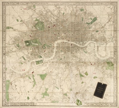
Lot 158 - London. Stanford (Edward, publisher), Stanford's Map of Modern London..., 1870
Sold for £1,800
Lot 159 - Maps. A collection of 30 British county, regional and country maps and charts, 17th - 19th century
Lot 160 - Maps. A mixed collection of 110 British county and regional maps, mostly 19th century
Lot 161 - Maps. A mixed collection of approximately 130 regional and county maps, 18th & 19th century
Lot 163 - Morden (Robert). A collection of 18 maps, 1695 or later
Sold for £260
Lot 164 - North America & Canada. A mixed collection of approximately 60 maps, mostly 19th century
Lot 165 - Nottinghamshire. Overton (H.), A New Map of Nottingham-Shire..., 1714
Sold for £120
Lot 166 - Ogilby (John). A collection of 6 maps, 1676 or later
Lot 167 - Ogilby (John). A collection of 7 maps, 1676 or later
Lot 168 - Ogilby (John). A collection of five road maps, 1676 or later
Lot 169 - * Oxfordshire. Speed (John), Oxfordshire described..., Roger Rea, circa 1662
Sold for £540